
Makara PeaK
Skills Park
Ride, Progress, Play
Brief
Location: Mākara Peak, Wellington, New Zealand
Land Manager: Wellington City Council (WCC)
Trail Care:Mākara Peak Supporters
Trail Standard: New Zealand Mountain Bike Trail Design & Construction Guidelines
Length: Within existing defined park boundary
The Mākara Peak Skills Park is part of a wider initiative by Trails Wellington to develop purpose-built mountain bike skills areas alongside existing trail networks. This conceptual design supports rider progression, encourages outdoor recreation, and fosters community engagement. The park will feature elements reflective of real bike park conditions to help riders build confidence and technique in a supervised environment. Developed in partnership with Wellington City Council, the design will guide stakeholder discussions and inform future planning stages.
Conceptual design within the defined park boundary to include:
Maintain access for service vehicles up to 16 m in length to the transmission tower
No earthworks permitted within 12 m of the tower base
Skill development features ranging from beginner to expert
Emphasis on replicating bike park features to support progression in a controlled environment
Short trails incorporating corners, rollers, drops, and mixed surfaces, ranging from Grade 2 to Grade 4, suitable for both rider development and coaching
Progressive drop section (Grade 2 to Grade 5), flowing left to right
Open area for free riding and beginner practice (e.g., manuals, bunny hops)
Grade 3 and Grade 4 jump lines
Jump sequences to include wide spacing, allowing beginners time to recover between features
Optional structures such as see-saws, raised skinnies, balance beams, shark fins, and wall rides—only if space permits
Rest and viewing area
Reuse of existing picnic table
Terrain ANALYSIS
The terrain was analysed using a high-resolution 1m LiDAR model and GIS software to identify optimal alignments for the skills park.
Satellite imagery is used to identify tree cover, and existing infrastructure.
Height mapping illustrates elevation changes across the site and helps determine ideal start and end points to maximise the available descent or ascent.
The site is already clear of vegetation and has hosted a jump track. Mapping results identified the north most point as the highest and a suitable launch point, and the south most as the lowest and an ideal finish point. These are already used in the current layout. The elevation difference and distance between them, will dictate the lengths of the trail possible.
LiDAR DEM Source: Land Information New Zealand - Wellington City LiDAR 1m DEM (2019-2020)
Scan Date: 2019
Resolution: 1m
Highest point: 228m
Lowest point: 223m
Elevation Difference: 5m
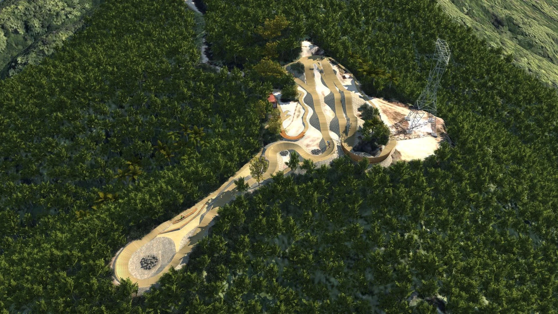
SITE Overview
In consultation with stakeholders, and based on the site’s topography and access requirements, the following layout has been identified as the most effective starting point for the Mākara Peak Skills Park:
Skills Development Zone (West):
Positioned close to the park entry and the existing picnic table, this area flattens out after the northern starting hill, making it ideal for beginner-friendly features and coaching activities. Riders can develop core skills without intersecting the faster, more advanced jump lines.Jump Lines – Grade 3 & 4 (East):
Located on the eastern side, this zone allows riders to carry momentum from the start hill into the jump lines. This layout supports a natural progression and ensures separation between beginner riders and those moving at higher speed, improving both safety and flow.
Design
The final layout for the Mākara Peak Skills Park balances progression, safety, and rider enjoyment while making the most of the available space within site constraints. Features are strategically grouped to support skill development from beginner to expert levels, with clearly defined trail zones, dedicated return paths, and an open area for free practice.
Design Features:
Start Hill
• 3.5m highSkills Trail Grade 3
Jump Line Grade 3
Jump Line Grade 4
Skills Trail Return
Jump Line Return
Wall Ride
Free Ride Area
A level open area for riders to practice bunny hops, manuals etc.
• 13m x 20m
• NOTE: remove existing two rail fence to allow free movement and prevent collisions.Rest Area
Park Bench and Potential to install shelter with water collection.Drop Grade 3 /Step Up Grade 4
• 0.2m high
• 1m wideDrop Grade 4 / Step Up Grade 5
• 0.4m high
• 1m wideEntry Drop Grade 4
• 0.5m high.
• Min 0.6m wideDrop Grade 5
• 1m high
• Min 0.4m wideSkills Trail Grade 2
• Small rollers and turns.
• Raised Timber deck and mini wall wallride.Rock Garden
• Small to large size rock lines to replicate those found throughout the park and develop balance skills. Includes a large rock drop & step up from skills track.Skinnies
• 300mm & 150mm Skinnies for balance practice.Rock Gap A-Line
• A line option on skills trail.

GPS TRACE

eXPLORE IN 3D
Skills Trail Grade 3
This entry-level skills trail is designed for beginners to master the fundamentals of cornering, pumping, and jumping in a controlled environment. While all rollers can be safely traversed with wheels on the ground, the trail provides a clear progression path; as riders increase their speed and power, they can practice the sensation of weightlessness and eventually gap the double rollers at the trail's end.
Advanced Trail Designs simulator, Flow Logic, shows riders maintain enough momentum, without having to pedal, to roll through the whole trail. Increasing power output to 220 watts gains slight air over the first rollers and lets you gap the last three double rollers.
Rollers to 1m high, which can be jumped with increased speed. Ramp angle up to 20°
Bermed corners, minimum 4m outside radius. Flat on inside, ramping up to 45° on the outside allowing for faster cornering speed as confidence increases.
All features roll-able
127m Long
2m Wide
Skills Trail Grade 2 - Telemetry
Jump Line Grade 3
Table tops with moderate height and ramp angles allow intermediate level riders the chance to develop their skills.
Advanced Trail Designs simulator, Flow Logic, shows from the start ramp riders maintain enough momentum to roll through the course without pedaling. Increasing your peddling power to 110 watts allows them to start clearing the table tops.
A timber wall ride at the end lets riders get higher and higher as they increase their speed and lean angle.
Table top jumps, 1.5m high, ramp angle 25°
13m spacing
2 - 2.5m long table tops
9m range landing ramp
74m Long
2m Wide
Jump Line Grade 4
Doubles with more height and steeper ramp angles give advanced riders the thrill they’re seeking, while still controlling risk by being fully roll-able.
Flow Logic, shows from the start ramp riders maintain enough momentum to roll through the course without pedaling. Increasing your peddling power to 160 watts allows them to start clearing the doubles.
The timber wall ride at the end catches them with their momentum getting them high.
Roll-able double jumps, 2m high, ramp angle 30°
14m spacing
2.4 - 3m roller double
9m range landing ramp
48m Long
2m Wide
Jump Line Grade 3 - Telemetry
Jump Line Grade 4 - Telementry
PLAN
References
Please help Advanced Trail Design by leaving a Google business review.
